Harrodsburg Area Geodes
Monroe County, Indiana
December 27, 2003
By Mike Streeter
mcstreeter@charter.net
We woke up early on Saturday excited to start our full day of geode hunting. We left our motel
room in Bloomington with great expectations. We were excited by the weather forecast that called
for a high temperature of 51 degrees, a full 15 degrees above normal - lucky us! We drove
south on Hwy-37 in the direction of Bedford to a high road cut just north of the Harrodsburg exit.
This location is well known for having plentiful geodes in the limestone walls. We drove up a
muddy two-track road on the north side of the west cut and parked in a level grassy field.
Although the rocks are essentially identical on both sides of the highway, we chose to work
the western side to take advantage of the sun that was rising in the eastern sky. Also, the
ice that was hanging down both cuts in large sheets and icicles was far less pronounced on the
western cut since it receives considerably more daily sun exposure.
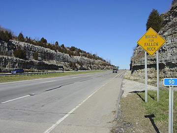
Harrodsburg Cut - looking North on Hwy-37
As a professional geologist and author of "A Rockhounding Guide to North Carolina's Blue Ridge
Mountains" (www.mcrocks.com), I am keenly interested in the geology of any area where we rockhound.
I discovered by studying the Indiana Geologic Survey's website (http://igs.indiana.edu/) that
the rock formation containing most of the area geodes is the Harrodsburg Limestone. Limestone
is a broad term that refers to sedimentary rock in which calcium carbonate is the major constituent.
Calcareous sediments, including the remains of marine animals, were deposited in a shallow sea
that covered most of what is now the continental United States during the Mississippian Period
that extended from 360 to 325 million years ago. The sediments would become buried and
compressed by overlying materials and cemented by calcium carbonate to form limestone.
Certain stratigraphic units within in the formation contain different types of fossils and
geodes. The fossils are the remains of extinct marine animals, including brachiopods,
crinoids and bryozoans. But how did the geodes form?
It is thought that many varieties of Indiana geodes began as cauliflower-like growths of gypsum that
had either been trapped or formed in the soft calcareous sediments. The outside of the gypsum
growths would gradually become encrusted with an outer shell of silica. The remaining interior
gypsum would later be dissolved by groundwater solutions leaving a quartz-lined cavity in the
limestone. At some later time, mineral-rich groundwater would make its way through rock fractures
and the crystallization of minerals would take place from the outside in. The two most common
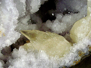
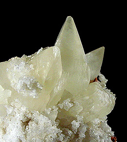
minerals to crystallize in the geodes are quartz and calcite. The crystallization of these two
minerals took place during separate phases with calcite generally being the latter. Other
more exotic minerals found in Indiana geodes include millerite, celestite, strontianite, barite,
pyrite and amethyst. It has also been postulated that geodes formed by the chemical
replacement of calcite nodules and iron concretions by silica. Knowing how geodes formed
may be interesting academically but finding them is the real fun.
According to the Indiana Geological Survey, there are many locations in Monroe County where geodes
may be found. Geodes may be found along the shores of Monroe Lake. Geodes may also be found
in and along streams that empty into that lake, including Stephens Creek (six miles east of
Bloomington) and Ramp Creek (east of Smithville). Other streams where geodes may be found in
Monroe County include Clear Creek (three to five miles south of Bloomington), and Jackson Creek
(two miles southeast of Bloomington to four miles south of Bloomington). Geodes can also be
extracted from the bedrock on Hwy-37 road cuts south of Bloomington. Geodes are commonly found
in ravines about the town of Bedford. Small geodes are reportedly abundant at the western
end of the railroad tunnel west of Unionville. Geodes may also be found in Brown County along
the banks of Bear Creek in the northwestern part of the county. Access to the stream is available
along Bear Creek Road north of the town of Trevlac. In Lawrence County, geodes can be found
along the banks and in Little Salt Creek, which runs through the northern part of the county.
Guthrie Creek and Back Creek, south of Leesville in eastern Lawrence County, are also good places
to hunt geodes.
It had heard that millerite and calcite could be found in geodes collected from the first ledge
above Hwy-37 on the Harrodsburg cut. So, that's where we headed along with Opal.
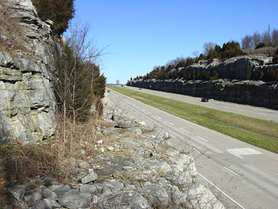
Looking North from the first ledge on Hwy-37 cut
We made our way down from the top grassy level at the southern end of the cut to the beginning of a
horizontal flat ledge that is about 7 feet wide and 20 feet above the road. As we continued
northward on the ledge, we came upon a few small cedar trees in our path that had to be carefully
scooted around. Beyond the trees, the ledge slopes markedly downward toward the road as it is
covered with a rock talus that includes countless broken geodes. Chrissy's pronounced fear of
heights prevented her from getting past the cedar trees, so she retreated from the ledge and
opted to collect in other areas where she didn't have to worry about taking a 20-feet header
if she tripped. Opal doesn't share Chrissy's fear of heights, so my canine friend kept me
company on the ledge. Her "four-wheel drive" serves her well on uneven and treacherous terrain.
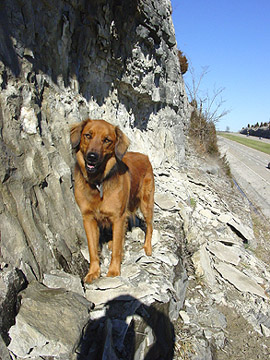
Opal Streeter
Just past the cedar tree, I found a couple fair sized geodes sticking part way out of the vertical
limestone wall. I noticed obvious chisel marks surrounding a 6" diameter geode indicating that
another rockhound had attempted to recover it. Although I should have taken the "hint" that this
geode would not be easily liberated, I began banging away around its sides with a pointed chisel
and 6-pound sledgehammer. After about 40 minutes, during which it seemed that I was getting
nowhere fast, I realized that maybe it would be a good idea to look around a little bit to
see if there were easier pickings. I am not generally one to quit but I didn't want to be there
two hours later with only one geode to show for my trouble. I discovered an area farther north
on the ledge where geodes were also partially exposed and where the rock seemed to be less dense
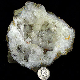
with more fractures. I discovered that many of the geodes in this section of the wall had
already been broken but were still in place and some contained excellent calcite crystals.
So, I went to work again trying to expose and recover geodes.
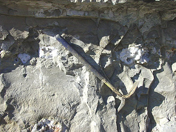
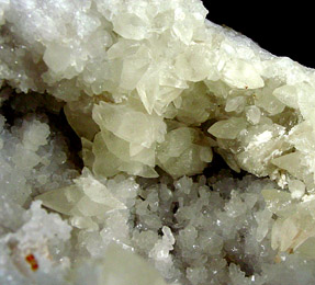
Close-up view of broken geodes in the dolostone wall
I worked for about 5 hours with a 4-feet long pry bar, pointed and flat chisels and 6-pound
sledgehammer. It appeared to me that one section of limestone had been weakened as water flowing
through internal fractures froze and swelled. The recent warm temperatures melted the ice leaving
behind expanded fractures and weaker rock. This enabled me to pry loose large vertical blocks
and sheets of limestone from the wall which, in turn, exposed geodes. Unfortunately, the melting
of the ice had another unpleasant effect that wasn't at all helpful to my cause. I had to
spend much of my time on the ledge working beneath a melting sheet of ice that continuously
dripped water and dropped ice fragments onto my head and shoulders. It was a good thing that
one of the larger icicles didn't let loose and hit me or I would have likely ended up falling
with it to the road below. This probably would have delighted any one of the many chuckleheads
in passing cars who felt compelled to honk his horn or holler an unintelligible expletive at me
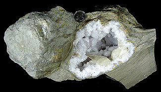
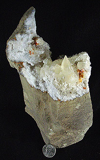
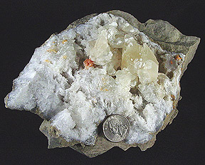
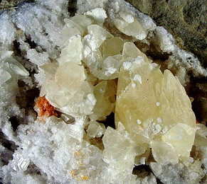
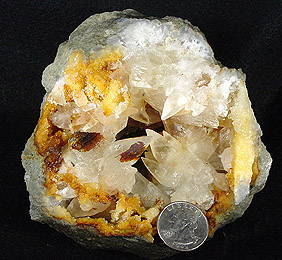
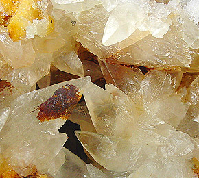
while I was working. My efforts and perseverance were rewarded with some fantastic geodes that
contain an assortment of minerals including quartz, calcite, pyrite and dolomite. I carefully
ferried each delicate specimen to the south end of the ledge where Chrissy felt comfortable
enough to tread. She collected the specimens, one in each hand, and carried them in many trips
up the hill to the truck. Chrissy did her usual bang-up job gently wrapping and securing all
the nice specimens.
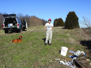
Chrissy and Opal at the top of the cut
|
Click on each specimen picture to enlarge
Click on each specimen picture to enlarge
| |
| |
At about 2:00 PM, we decided that we had gotten more than our share of goodies from this location
and we were hungry. So, we packed up our stuff and drove about 15 miles south on Hwy-37 to Bedford
to look for our good friend, Ronald McDonald.
From Bedford, we headed east on Hwy-50 and north on Hwy-446 to another road cut that is reportedly
ripe with geodes containing pink calcite. We poked around this location for about an hour and
a half and didn't find much of anything before giving up for the day. We saw lots of opportunities
but, by then, we were both too tired to expend much more energy. We left this spot and drove in
a westerly direction on twisting back roads with a plan to do more collecting near Monroe Lake but
we ran out of sunlight before we got there. We were, however, treated to a wonderful late afternoon
view of the lake.
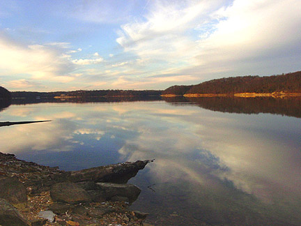
Monroe Lake
Click on picture to enlarge
We spent another comfortable night in Bloomington and left very early
on Sunday in an attempt to beat the holiday traffic back home. As is usual after one of our
rockhounding adventures, the back of the truck rode a little closer to the ground, but we
weren't complaining.
CLICK THE LITTLE MINER TO RETURN TO THE FIELD TRIP PAGE